 |
Cacti dominate the Sonoran Desert vegetation near Tucson, Arizona. |
 |
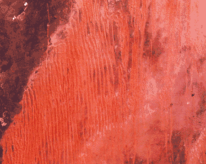
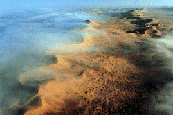
Ripples on a dune in the Gran Desierto, Mexico. |
 |
Distribution of non-polar arid land (Click on image to see full map) |
| |
Cacti dominate the Sonoran Desert vegetation near Tucson, Arizona. |
| |
Ripples on a dune in the Gran Desierto, Mexico. |
| |
Distribution of non-polar arid land (Click on image to see full map) |
On a planetary scale, the circulation of air between the hot Equator and the cold North and South Poles creates pressure belts that influence weather. Air warmed by the Sun rises at the Equator, cools as it moves toward the poles, descends as cold air over the poles, and warms again as it moves over the surface of the Earth toward the Equator. This simple pattern of atmospheric convection, however, is complicated by the rotation of the Earth, which introduces the Coriolis Effect.
To appreciate the origin of this effect, consider the following. A stick placed vertically in the ground at the North Pole would simply turn around as the Earth rotates. A stick at the Equator would move in a large circle of almost 40,000 kilometers with the Earth as it rotates.
The Coriolis Effect illustrates Newton's first law of motion--a body in motion will maintain its speed and direction of motion unless acted on by some outside force. Thus, a wind travelling north from the equator will maintain the velocity acquired at the equator while the Earth under it is moving slower. This effect accounts for the generally east-west direction of winds, or streams of air, on the Earth's surface. Winds blow between areas of different atmospheric pressures.
The Coriolis Effect influences the circulation pattern of the Earth's atmosphere. In the zone between about 30° N. and 30° S., the surface air flows toward the Equator and the flow aloft is poleward. A low-pressure area of calm, light variable winds near the equator is known to mariners as the doldrums.
 The circulation pattern of the Earth's atmosphere. Most of the nonpolar deserts lie within the two trade winds belts. |
The surface air that flows from these subtropical high-pressure belts toward the Equator is deflected toward the west in both hemispheres by the Coriolis Effect. Because winds are named for the direction from which the wind is blowing, these winds are called the northeast trade winds in the Northern Hemisphere and the southeast trade winds in the Southern Hemisphere. The trade winds meet at the doldrums. Surface winds known as "westerlies" flow from the Horse Latitudes toward the poles. The "westerlies" meet "easterlies" from the polar highs at about 50-60° N. and S.
Near the ground, wind direction is affected by friction and by changes in topography. Winds may be seasonal, sporadic, or daily. They range from gentle breezes to violent gusts at speeds greater than 300 kilometers/hour.
 |
| These dunes in the Algodones Sand Sea of southeastern California move as much as 5 meters per year. The dunes in this photograph, looking south, move toward the east (left). |
 |
| Searles Lake, California. (Photograph courtesy of Kerr-McGee, Inc.) |
 |
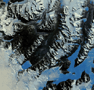
| The Garlock fault, near the bottom of this Landsat image, is generally considered to be the geologic border between the Mojave Desert in the south and the Great Basin Desert in the north. The Great Basin contains more than 150 discrete desert basins separated by more than 160 mountain ranges. |
 | The trade winds in two belts on the equatorial sides of the Horse Latitudes heat up as they move toward the Equator. These dry winds dissipate cloud cover, allowing more sunlight to heat the land. Most of the major deserts of the world lie in areas crossed by the trade winds. The world's largest desert, the Sahara of North Africa, which has experienced temperatures as high as 57° C, is a trade wind desert. |
| The Sahara of Africa is the world's largest desert. It contains complex linear dunes that are separated by almost 6 kilometers. (Skylab photograph). |
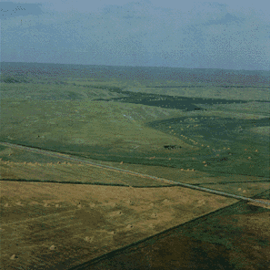
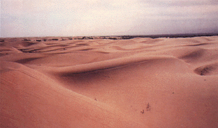 | Midlatitude deserts occur between 30° and 50° N. and S., poleward of the subtropical highpressure zones. These deserts are in interior drainage basins far from oceans and have a wide range of annual temperatures. The Sonoran Desert of southwestern North America is a typical midlatitude desert. |
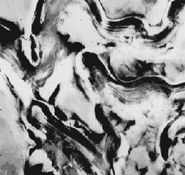
| A rare rain in the Tengger, a midlatitude desert of China, exposes ripples and a small blowout on the left. Winds will shortly cover or remove these features. |
 | Rain shadow deserts are formed because tall mountain ranges prevent moisture-rich clouds from reaching areas on the lee, or protected side, of the range. As air rises over the mountain, water is precipitated and the air loses its moisture content. A desert is formed in the leeside "shadow" of the range. |
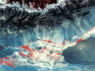
| This Landsat image shows the Turpan Depression in the rain shadow desert of the Tian Shan of China. A sand sea is in the lower center on the right, but desert pavement, gray in color, dominates this desert. The few oases in the desert and the vegetation in the mountains at the top are in red. A blanket of snow separates the vegetation in the Tian Shan from the rain shadow desert. |
 |
| Crescent-shaped dunes are common in coastal deserts such as the Namib, Africa, with prevailing onshore winds. Low clouds cover parts of the Namib in this space shuttle photo. |
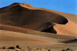 |  |
| High dunes of the Namib desert near Sossus Viei (photograph by Georg Gerster). | Morning fog moistens the dunes of the Namib coastal desert (photograph by Georg Gerster). |
 | "Monsoon," derived from an Arabic word for "season," refers to a wind system with pronounced seasonal reversal. Monsoons develop in response to temperature variations between continents and oceans. The southeast trade winds of the Indian Ocean, for example, provide heavy summer rains in India as they move onshore. As the monsoon crosses India, it loses moisture on the eastern slopes of the Aravalli Range. The Rajasthan Desert of India and the Thar Desert of Pakistan are parts of a monsoon desert region west of the ranqe. |
| The Indus River floodplain, lower left, is the western border of the Thar Desert. This Landsat image of the monsoon desert shows small patches of sand sheets in the upper right, with three types of dunes; some dunes are almost 3 kilometers long. |
 | Polar deserts are areas with annual precipitation less than 250 millimeters and a mean temperature during the warmest month of less than 10° C. Polar deserts on the Earth cover nearly 5 million square kilometers and are mostly bedrock or gravel plains. Sand dunes are not prominent features in these deserts, but snow dunes occur commonly in areas where precipitation is locally more abundant. Temperature changes in polar deserts frequently cross the freezing point of water. This "freeze-thaw" alternation forms patterned textures on the ground, as much as 5 meters in diameter. |
| The Dry Valleys of Antarctica have been ice-free for thousands of years (courtesy of USGS Image Processing Facility. Flagstaff. Arizona). |
Fossil desert sediments that are as much as 500 million years old have been found in many parts of the world. Sand dune-like patterns have been recognized in presently nonarid environments. Many such relict dunes now receive from 80 to 150 millimeters of rain each year. Some ancient dunes are in areas now occupied by tropical rain forests.
The Nebraska Sand Hills is an inactive 57,000square kilometer dune field in central Nebraska. The largest sand sea in the Western Hemisphere, it is now stabilized by vegetation and receives about 500 millimeters of rain each year. Dunes in the Sand Hills are up to 120 meters high.
 |  |
| This aerial photograph of the Nebraska Sand Hills paleodesert shows a well-preserved crescent-shaped dune (or barchan) about 60 to 75 meters high. (Photograph by Thomas S. Ahlbrandt) | A dry community of vegetation grows among the dunes of the Nebraska Sand Hills. (Photograph by N.H. Darton) |
 |
| This Viking spacecraft image of Mars shows alternating layers of ice and windblown dust near the north polar cap. Annual and other periodic climatic changes due to orbit fluctuations may occur on Mars (courtesy of USGS Image Processing Facility, Flagstaff, Arizona). |
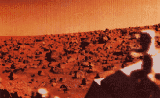 |  |
| One of the first images taken at the Viking 2 landing site on Mars shows the pink sky over Utopia and the desert pavement on the ground (courtesy of NASA). | Some of the crescent-shaped dunes in this Viking image of Mars are more than a kilometer wide. The dark material that streaks from the horn-shaped features may be dust recently blown from the dunes (courtesy of NASA). |